hundred and forty kilometer long channel.


The scale of Enbridge’s misrepresentation is put into context in figure three, which shows the geographical length of Douglas channel, as one hundred and forty kilometers long.

Enbridge deleted 1000 km2+ of Douglas Channel Islands from route animations
JRP talk and visuals - Enbridge Northern Gateway - Joint Review Panel Public Hearing, January 11, 2013. | Main page |
Lori Waters, MFA, MScBMC
My name is Lori Waters, and I’m a medical and scientific illustrator and animator. I was born on Vancouver Island and I’ve
lived here most of my life. I hold a masters degree in Fine Arts, and a Masters of science degree specializing in scientific
animation from the only accredited biomedical visualization program in Canada, at the university of Toronto. I have also
taken courses in marine biology as the proximity to, and vital importance of the ocean here means that I have recently
been called upon to do increasing amounts of scientific animation for oceanography. I have created geographical and
oceanographic 3D animations for federal organizations, including the department of Fisheries and oceans, and won an
award for the public displays and animations I designed and produced for Sidney’s institute of ocean sciences, in honour
of the visit of the Emperor of Japan.
My presentation today concerns Enbridge information materials, particularly two geographical Northern Gateway route
animations entitled “route video” and “route safety”, which I first viewed last August.
I will use procedural direction six to use visuals to show details of Enbridge animations. The visuals are also online at
watersbiomedical.com/islands. The four main reasons to discuss Enbridge’s animations are as follows:
Much of what I am going to share with you is a technical explanation, but I hope to illustrate for the panel that information
put forth by Enbridge in the form of animations deserves scrutiny. 3D animation is a highly technical field, where deliberate
choices and painstaking labour results in animations that appear to take place in a virtual world.
3d animations involve the creation of a 3D model in virtual space in a program such as Maya. The virtual models are then
surfaced with texture or colour, and lit with virtual lights. The scene is then “filmed” by virtual cameras that move through
the space. Eventually, each frame of the camera movement is captured and flattened or “rendered” into an individual image.
These are then composited in series, along with sound or video, to make a final movie. Animations typically take months to
produce from start to finish. What I’d like you to keep in mind is that every part of an animation must be deliberately created.
Last August, I also sent my observations to the Canadian Competition Bureau in a complaint regarding Enbridge’s animations,
and I requested an investigation of Enbridge for false or misleading advertising, as section fifty-two of the Competition Act
states in part that:
“No person shall, for the purpose of promoting, directly or indirectly,… any business interest, by any means whatever,
knowingly or recklessly make a representation to the public that is false or misleading in a material respect.”
Regardless of this law, Enbridge animations grossly misrepresent the geographical attributes of the project route through the
Douglas Channel, omitting over 1000km2 of islands from the geographical model. Yet multiple islands and navigational hazards
in Douglas Channel are important considerations regarding Enbridge’s claims about tanker route safety.
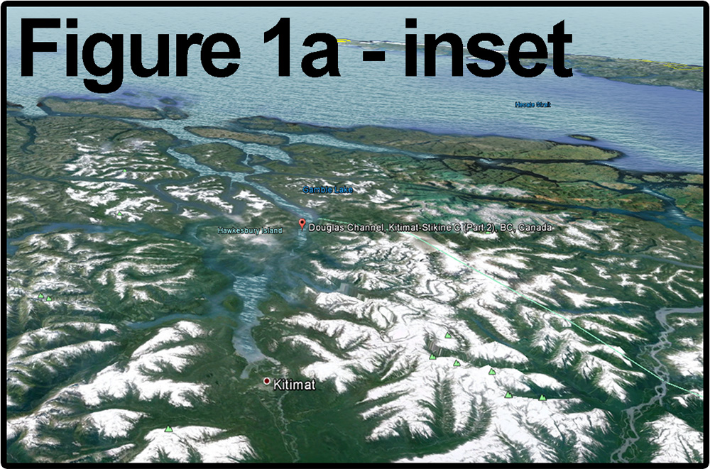
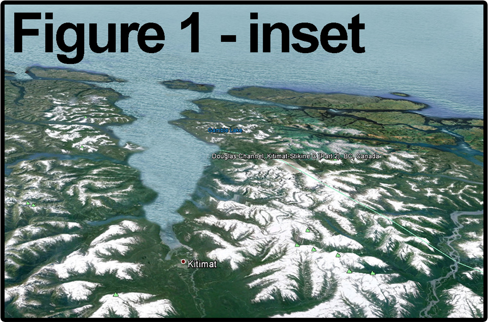
| Figure one shows you a screenshot of Enbridge’s animated depiction of Douglas Channel. There are no islands shown in the one hundred and forty kilometer long channel. |
|
| In figure one “a”, I replaced the islands to demonstrate what the view of the channel should look like. | |
| Inset 1a shows you the Google Earth view, seen from the same viewpoint as the Enbridge animations. | |
| Conversely, Figure 1’s inset shows you an altered version of Google Earth, to show how the channel would look in Google earth, if the Enbridge depiction was real. | |
|
|
| Reinforcing this, figure two shows how a Canadian government marine chart would look if the islands Enbridge removed didn’t exist. Figure 2a is the same chart, intact. | |
The scale of Enbridge’s misrepresentation is put into context in figure three, which shows the geographical length of Douglas channel, as one hundred and forty kilometers long. |
|
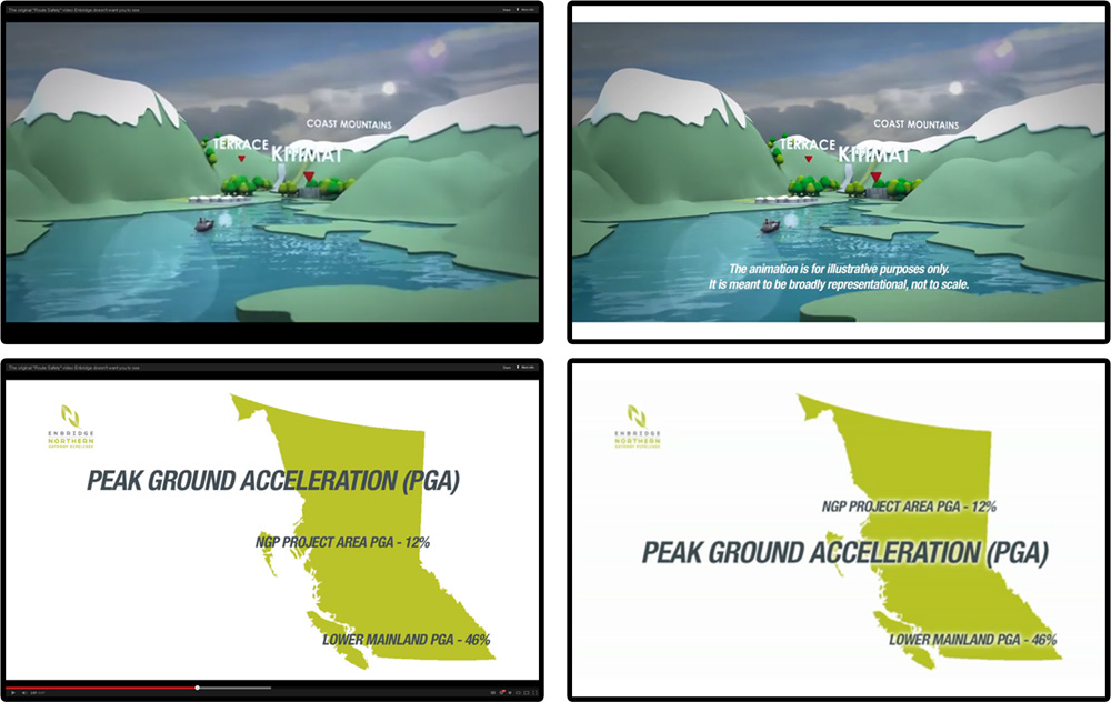
I acknowledge that Enbridge’s animation originally contained a disclaimer stating that the animation is for illustrative purposes
only, that it was meant to be broadly representational, and not to scale. However, I submit that what Enbridge has deliberately
done is take an accurate geographical model, placed some out-of-scale cartoonish trees and other cutesy features onto its model,
in order to make statements that the model is not to scale, perhaps in hope that the disclaimer would then save them from their
gross omission of the islands. The creation of a gaping channel by deleting the islands misrepresents the twisting and jagged
nature of Douglas Channel, and is not representative of a “confined channel” as it is more accurately labelled in the technical report.
The enchanted fairy-tale appearance of the out-of-scale cartoon trees and other models detracts from the seriousness of the
subject, and are in themselves misleading because their cloying cartoon nature has the effect of lulling the public into a false
sense of security by presenting a “friendly” simplified representation which is simply not reflective of a major pipeline carrying
toxic bitumen and condensate.
| To demonstrate that Enbridge used a scale model as the basis for their animation, I have highlighted several areas on figure four “a”, which is a screenshot of their model that appears at the beginning of their route animation. | 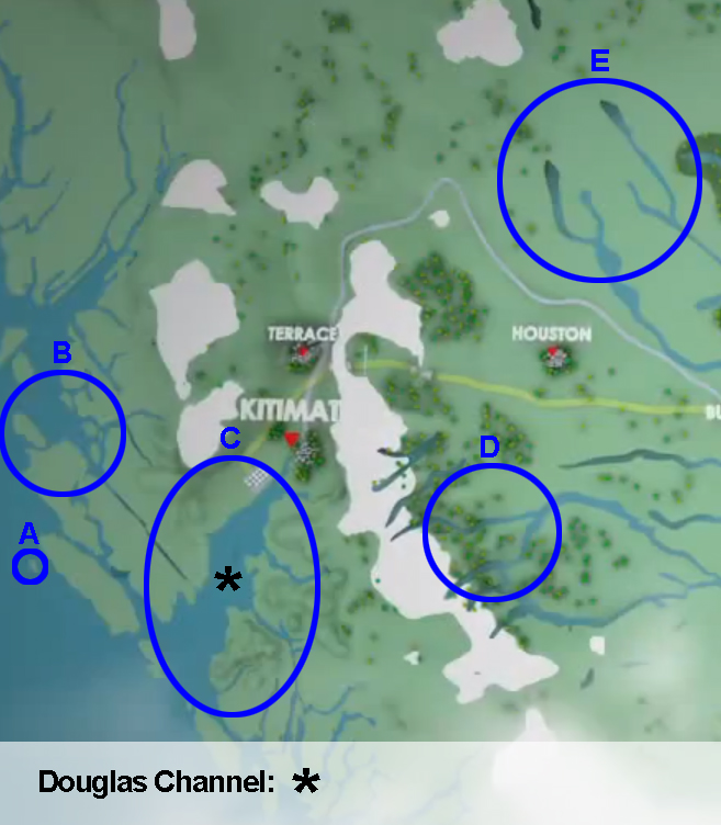 |
| These same points are then compared against a map of British Columbia, in figure four “B”. |  |
The fact that small islands on the coast such as Bonilla at circle“A” (off banks island), Stephens and Porcher islands at circle “B”
remain intact, as well as rivers and lakes such as Nechako at “D” and Takla and Babine at “E” are all shown accurately, and to
scale, and the fact that these geographical reference points match the map closely tells me that Enbridge created their animations
from an accurate scale model. This is unsurprising, given that geographical data is readily available, and is typically accurate as
it is usually created by governmental science organizations. The only noteable inaccuracy in the overall Enbridge geographical
model is that the islands on the tanker route shown at “C” have been deleted.
Enbridge’s spokesperson has responded to this criticism stating that the animation was not meant to depict the tanker route, but
I find this response rather odd, given that it is a proposal route animation and that it shows a tanker, mid channel, in the gaping
maw created by Enbridge’s deletion of the islands.
Several of the islands I pointed out earlier, you will note, are smaller than those that have been deleted, yet they are still in the
model. I submit that some islands were left because they were not in the tanker route, and therefore were not positioned to
detract from the preferred visual appearance of safety desired for project promotion.
| Earlier, I said that there is no technical explanation for the deletion of the islands. Figure four “c” reinforces this, as it is a screenshot of the marine safety animation. This shows that Enbridge is capable of creating and using accurate models of the channel route when it chooses. | 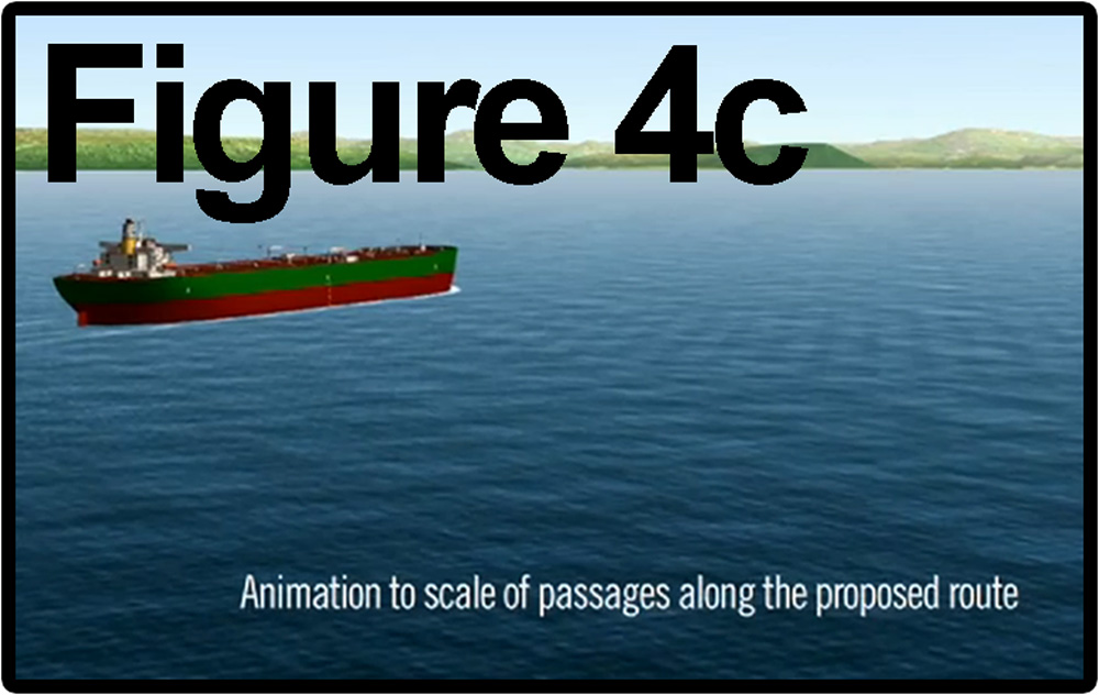 |
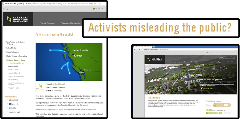
Enbridge knew that the depictions were misleading, because in response to public reaction once my map images went viral,
Enbridge inserted disclaimers over the three dimensional animation.
They also altered the two dimensional simplified scale maps of BC that appeared in the animations, moving text over the area
where the islands had also been deliberately removed from these graphic maps. There were no disclaimers on these maps, and
I submit that there is less justification for deleting islands off a two dimensional map graphic – particularly when Enbridge has
also shown that they have access to accurate 2D maps, such as the one depicted on the same blog webpage where they accuse
activists of misleading the public – the blog Enbridge created in response to criticism of the route animations.
Following these initial responses, Enbridge then embarked on a pervasive ad campaign that continues to drive people to the
Enbridge “public education” website with its uncorrected animations.
The public response to the misrepresentation has included international television, web, and print media coverage, showing of
the images at a UN meeting in Italy, editorial cartoons, protests, petitions and a poll. I along with the organization SumOfUs
delivered a petition to Enbridge with over 45,000 signatures asking that the misleading animations be removed. Enbridge,
despite its promise to do so, has not responded to the petition.
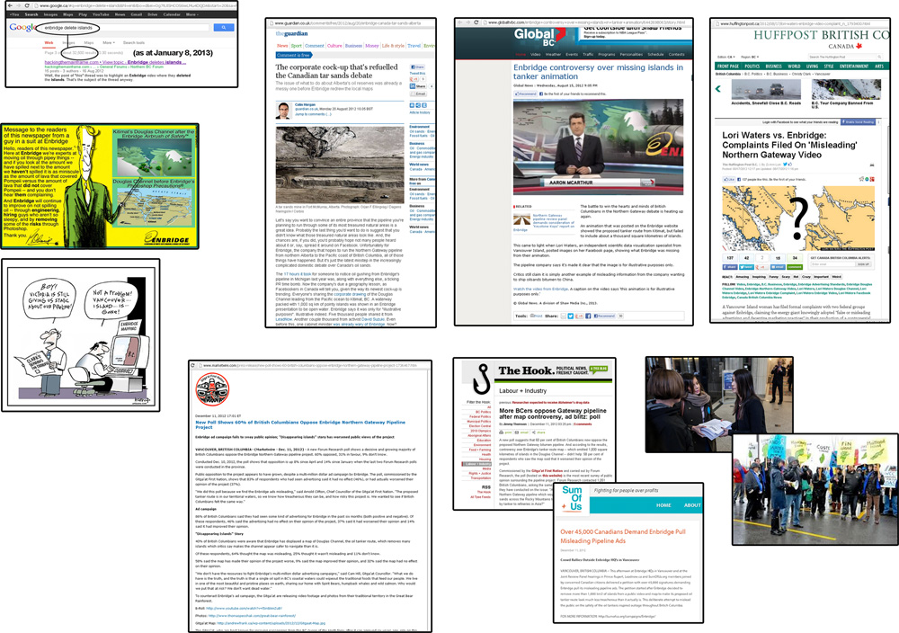
Lastly, a poll conducted by the Gitga’at first nation showed that sixty percent of British Columbians now oppose Enbridge’s
proposal, and that opposition increased after the map controversy. In my view this is because our citizens want and deserve
to be told the truth about risky proposals. British Columbians aren’t fooled. Please carefully scrutinize all information provided
by Enbridge. Please do not approve this project as it could cause an irrecoverable disaster on our coast.
Links:
Other recent items of interest:
Thank you to all of the individuals and organizations who help protect our coast.
Thanks to West Coast Environmental Law, UVic Environmental Law Centre, Gitga'at, LeadNow, SumOfUs,
the Vancouver Observer, Dan Murphy,
David Shortt, The Tyee, Sierra Club, Raincoast, the Dogwood Initiative,
David Suzuki, Elizabeth May, Nature Canada,
and *everyone* who cares about our coast.