Enbridge deleted 1000 km2+ of Douglas Channel Islands from route animations
Supporting visuals - Enbridge Northern Gateway - Joint Review Panel Public Hearing, January 11, 2013. | Main page |
Lori Waters, MFA, MScBMC
I'm providing the images below for the benefit of those listening who are unable to be present at the venue because of
the arbitrary venue changes that occurred in Victoria precluding citizens from hearing each other directly.
Please feel free to
contact me if I can answer any questions.

Figure one is a screenshot from Enbridge's animations, completely bereft of islands in the tanker route. Note that
although Enbridge says the animations have nothing to do with tankers or the tanker route, that there is a tanker
present in the gaping channel created by their removal of the islands.

Figure 1a shows a closer approximation of what the animation of Douglas Channel would look like, had its islands
been left intact.
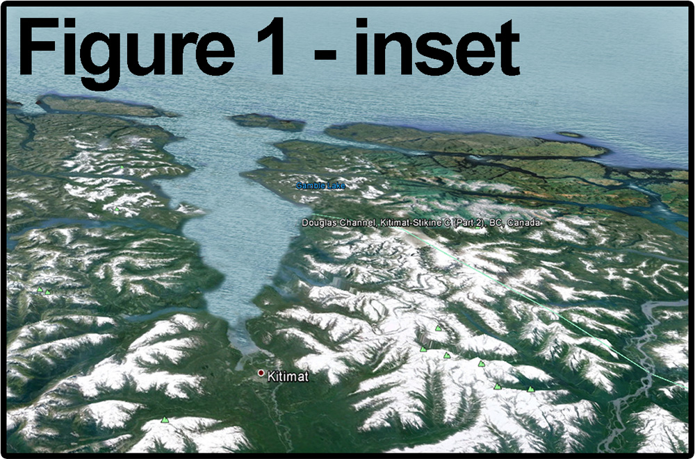
Figure 1 inset is a modified image from Google Earth to show how the Google Earth image would appear if
the fairytale Douglas Channel represented in Enbridge's animations was actually real.
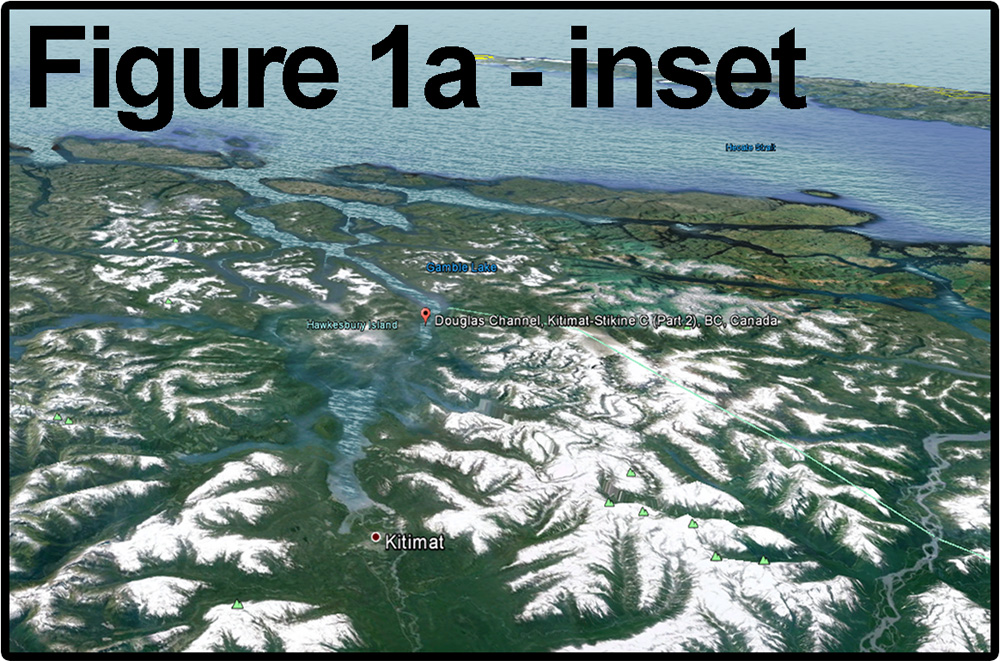
Figure 1a inset is a view of the Douglas Channel in Google Earth, matching the altitude and attitude shown in
Enbridge's animations, to demonstrate more closely what the geography looks like in reality, eg: with islands.

Figure 2 is a modified version of a Canadian Hydrography Services (CHS) marine chart of Douglas Channel, only
this version is modified to remove the same islands that Enbridge removed. Figure 2a is the same portion of the
same marine chart of Douglas Channel, showing the islands that actually exist there - including Gil Island, that was
hit by the Queen of the North, causing its sinking. Note that some of the islands that Enbridge chose to remove
were mid-channel
marine hazards.
The list of islands deleted by Enbridge is below, along with their land areas.
| ISLAND |
km² |
|
|
| Hawkesbury |
366.45101 |
| Gil** |
236.17699 |
| Campania |
168.29901 |
| Loretta |
11.7315 |
| Maitland |
40.7472 |
| Kitsaway |
5.35 |
| Fin* |
11.7068 |
| Williams |
0.35 |
| Hinton |
5.57125 |
| Promise |
13.5391 |
| Farrant |
58.25 |
| Ashdown |
4.6 |
| Coste |
11.0712 |
| Gribbell |
206.678 |
| Dorothy* |
1 |
| Emilia* |
0.35 |
|
|
| TOTAL LAND MASS km² |
1141.87206 |
|
|
| ** Was hit by, and sunk, BC Ferries Queen of the North |
| * Islets with small land areas, but which are mid-channel navigational hazards |

Figure 3 shows the scale of Douglas Channel to put in perspective the scale of the the islands Enbridge deleted.
From Kitimat to the outer coast is 140 kilometres.
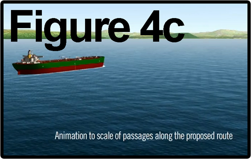
Figure 4c. Enbridge not only had access to accurate models, they've used them in other cases. Therefore, there is
no reason - technical or financial - for them to have purposefully deleted the islands from specific animations on
their public information website
- unless
their motivation was to make the marine route appear safer than in reality.
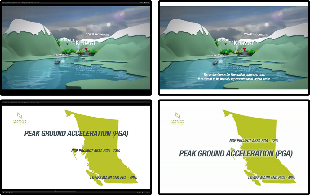
After the set of images I posted on my facebook page went viral in August of 2012, Enbridge quickly responded by
making some initial bandaid fixes to the animations. The top two frames (original at left and altered at right) shows
how they placed their disclaimer prominently over the animated channel with tanker.
Another significant alteration (there were others as well) was to shift the "PEAK GROUND
ACCELERATION (PGA)"
wording down in the two dimensional map frames, to cover up the fact that they also deleted the islands from the
two dimensional graphic. Note the gaping "Douglas Channel" hole (where the islands should be) in the left frame,
just below the "E" in "PROJECT." The corrected frame uses the text to hide the fact that the islands were deleted
in the 2D version as well. It would be very difficult to find any technical reason for having deleted islands from a
flat computer graphic.
My complaint to the Competition Standards Bureau details other bandaid revisions.
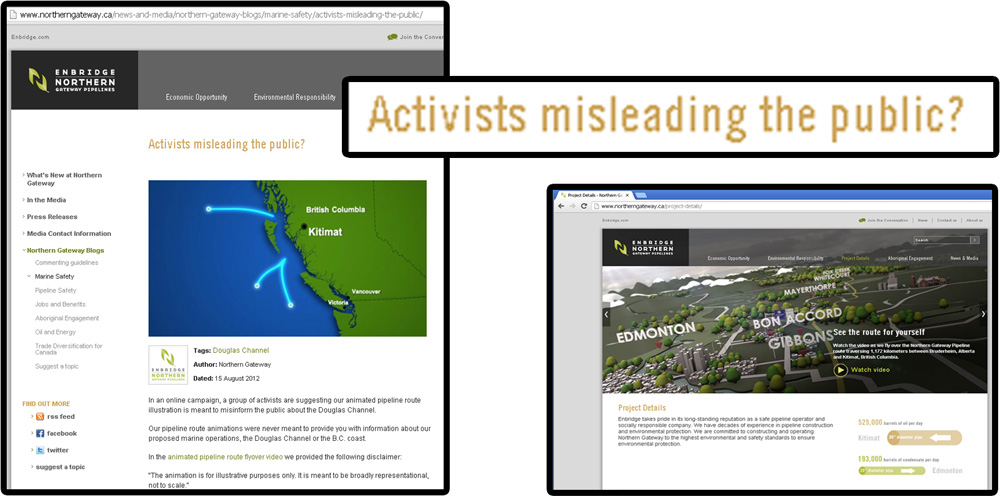
Enbridge's response, in addition to immediately changing the videos, was to then post a blog entitled:
"Activists misleading the public?" On this page, they took care to include the islands in their map, demonstrating
that they are able, when they want to, to accurately represent geography.
Their northern gateway "project details" webpage still contains animations with the errors noted above, and the
webpage still plainly states that members of the public can "see the route for yourself," implying that the animation
is correct.
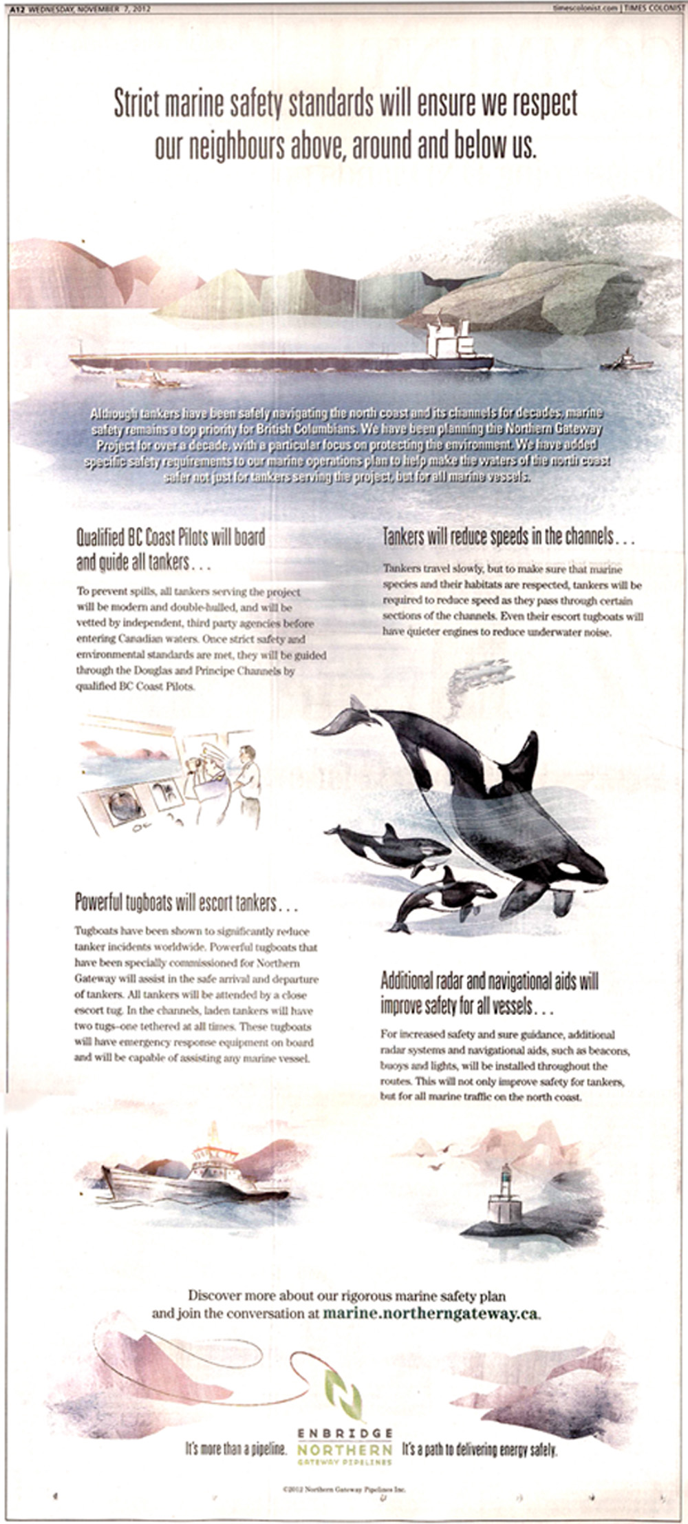
Enbridge also responded to the negative PR by launching a multi-million dollar advertising campaign, such as the
print ad below. It details marine operations over which Enbridge will have absolutely no control.
Enbridge is welcome to place as many wispy cloying pastel advertisements as they like about their toxic bitumen
and condensate pipeline proposal. British Columbians are not fooled by pastel drawings.
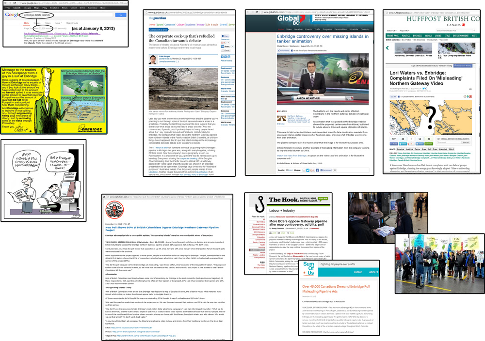
The public and media response to the missing islands has been voluminous: print, web, television, editorial cartoons,
protests, petitions (including a petition with over 45,000 signatures which myself, SumOfUs+, and a group of citizens
presented
to Enbridge, asking them to remove the misleading animations - Enbridge promised to respond, but
has not to date), and a poll commissioned by the Gitga'at First Nation, which showed that 60% of British Columbians
are opposed to the Enbridge Northern Gateway proposal, and that our
opinion of the project has plummeted since
Enbridge's
island controversy.
British Columbians deserve to be told the truth, and I appreciate all the hard work of so many individuals who have
collectively endeavored to ensure that the truth is told about proposal. The risks are far too great. If the project
were to go ahead, a marine oil spill disaster would cause *irreparable harm*. Rule number one: Do no harm.
Links:
Other recent items of interest:
Complaint to Competition Standards Bureau
Thank you to all of the individuals and organizations who help protect our coast.
Thanks to West Coast Environmental Law, UVic Environmental Law Centre, Gitga'at, LeadNow, SumOfUs,
the Vancouver Observer, Dan Murphy,
David Shortt, The Tyee, Sierra Club, Raincoast, the Dogwood Initiative,
David Suzuki, Elizabeth May, Nature Canada,
and *everyone* who cares about our coast.